
How Surveyors Create Easements?
Land surveyors often create easements and illustrate them on plans of survey for many intended uses. The fact that the surveyor produces the geometry for easements and positions them on a particular parcel of land, does not mean that an easement has been created. The drawing is merely a document to be used by the owner of the land, and the person desirous of the easement as the basis for an agreement. An easement is an agreement that requires the granting of certain rights from one party to another.
The terms 'easement' and 'right-of-way' (r-o-w) are often used interchangeably. Rights-of-way can be used as a right of use over another's land, or they can also be held in fee simple as a stand alone parcel of land. One example is public streets shown on survey plans and deeded from a developer to the municipality. Very seldom is a public street merely a right of passage. If there hasn't been a conveyance of the street, it may be interpreted as being owned by the municipality by virtue of long term usage, and the expenditure of public funds for maintenance. This philosophy is supported by the Public Highways Act; section 11(1) & (2) and noted as follows:
HIGHWAY BOUNDARIES AND TITLE
Deemed common and public highway
11 (1) Except insofar as they have been closed according to law,
(a) all allowances for highways made by surveyors for the Crown;
(b) all highways laid out or established under the authority of any statute;
(c) all roads on which public money has been expended for opening, or on which statute labour has been performed prior to the twenty-first day of March, 1953;
(d) all roads passing through Indian lands;
(e) all roads dedicated by the owners of the land to public use;
(f) every road now open and used as a public road or highway; and
(g) all alterations and deviations of, and all bridges on or along any road or highway, shall be deemed to be common and public highway until the contrary is shown.
Vesting in Crown
(2) Every common and public highway, together with the land within the highways boundaries, is vested in Her Majesty in right of the Province.
The ownership of the public right-of-way also cannot be infringed upon, or acquired through possession by adjacent land owners under the authority of the Municipal Government Act, section 50(4) as follows:
Powers of municipality regarding property
50(4) Possession, occupation, use or obstruction of property of a municipality does not give an estate, right or title to the property.
Another example may be a powerline or pipeline corridor that is acquired by title, or such rights, may be acquired by agreement while the ownership is not transferred. This type of rights-of-way could be labeled an easement. The common interpretation is that an easement is a corridor over land that conveys certain rights to the user, but not a transfer of ownership. Having said that, there are certainly separate parcels of land acquired for easement purposes for which title in fee simple is transferred. Ditches created for highway runoff and storm drainage are two examples. Another may be land required for a municipal sewer or water pumping station.
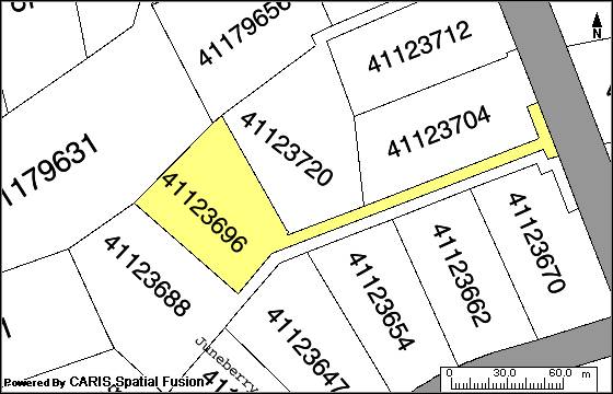
Present day subdivision regulations require that many right-of-ways or easements be created in order to facilitate the development of property. Easements may also be illustrated and created to assist in the usage of the lots being developed in response to the subdivision configuration. Lot frontages and areas are often manipulated to comply with the subdivision by-laws when flag/key lots are designed. Such irregular shapes present a challenge for the land surveyor to generate easements over various parcels for driveway access, power and telephone utility poles or municipal services. The subdivision lot configuration may be completed according to the municipality's subdivision by-laws, but topography may very well be the controlling factor in the positioning of easements. Topography may also require that lot configurations be altered to accommodate the easements necessary for the enjoyment of the property under development. Figure 1 is an example of what is termed 'key' or 'flag' lots. Such configurations normally require common driveways that may serve two or more lots. The geometry of these lots make it impossible to access the property with a vehicle, without the benefit of an easement.
PROVINCE OF NOVA SCOTIA PROPERTY MAP
Figure 1
The land surveyor must, as a function of professional responsibility, illustrate accurate geometry on a plan of survey. If an easement is to be created over a lot, it should be accurately positioned and described on the plan. A statement on the plan that a 12 foot +/- wide r-o-w is required over the subject lot is an inadequate description. The plan must show that the 12 feet is fully dimensioned in both length and width and accurately positioned with respect to the lot. The actions of the land surveyor should not result in ambiguity as to the location of the easement when being created. The land surveyor is certainly a major player in the creation of easements by the illustration on plans of survey, be that for subdivision purposes or access of some form, but action is still required by the owner of the land in granting a right to another party.
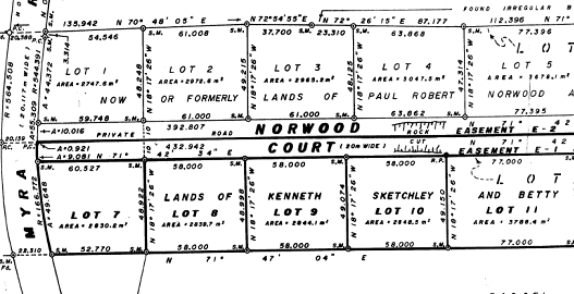
Figure 2 illustrates an example of an easement created for private road access to lots in compliance with local subdivision by-laws. The lots front on the easement or rights-of-way, but the r-o-w ownership remains vested with the original developer, unless transferred to another party. The main concern with such private roads is that they are not eligible for municipal services such as maintenance, snow removal or garbage collection. This means that someone must take responsibility for such services, and there are often land owners who do not wish to share in the financial responsibility, and that can create tensions within the neighbourhood.
Portion of Halifax County Registry Plan # 25595
Figure 2
Easements and rights-of-way create an intrusion upon an existing property and have the potential to limit the activity of the owner. Individuals presented with the option from another party desirous of an easement over their property, should give it serious consideration since it may also have an economic impact on the value of the parcel under ownership. An easement or r-o-w held by another party seldom benefits the land owner and sometimes results in friction as a result of the usage. One not only needs to be concerned with the easement's location, but its purpose when being created. How long should the easement exist? Who can use it and is it transferable? Purchasers considering buying property that is subject to rights, held by others, need to be fully cognisant of the easement and the role that it might play in the enjoyment of the parcel. These concerns are not generally depicted on the survey plan, but form part of the agreement between the land owner (servient tenant) and the easement user (dominant tenant). Keep in mind that the legal terms referred to here indicate that the land owner becomes the servant and must bow to the rights of the easement holder. An easement is deemed to be a burden recorded against the subject property and a benefit for the party granted the easement.
The interpretation and positioning of existing easements is a totally different matter. It presents its own challenges and is the subject of the next section.
What Is Involved in Trying to Fit a Titled Easement on the
Ground?
What Should You Look for When You Are On-Site Doing a
Survey?
Land surveying is part science and part art. The science part deals with mathematics, geology, geography and being able to state opinions based on fact. The art part is a combination of experience, the interpretation of common & statute law, and the assessment of evidence in order to offer an opinion on the extent of title or location of interests.
The review of documents coupled with on-site inspection of property is primarily used by the surveyor in forming an opinion as to location. The reliance on local knowledge of area residents, or parole evidence, is also often assessed, but reliance on this information must take a back seat to descriptions as per titled documents. The reason being, that memories fade with time and some of the recollection may not relate to first-hand experience.
There are two elements to the placement of an easement with respect to a property description. The first element requires that the description of the land that is held in fee simple is capable of being positioned without ambiguity. The second element is that the easement description is described in such a manner that it can be positioned on the titled parcel with confidence. The surveyor may be able to relate the easement to the lot boundaries as per the description, but lacks evidence as to the boundary location as a result of ambiguity in the description, or being able to find a suitable 'point of beginning'.
Beginning at an X on a granite boulder may sound great, but only if you can find the granite boulder. The same might be said for the corner as described as being marked as "BEGINNING at the southwest angle of a meadow lot" as described by an 1855 description, and presently recorded in Book 4667 at Page 895 in the Halifax County Registry. This description lacks definition due to a required interpretation of determining a certain corner of a meadow lot. The on-site investigation of this property in the late 1980's did reveal evidence of the said corner, being a mound of rocks and the remains of a squared post, reportedly placed during a 1946 survey of the adjacent property. An interesting fact about decaying wood and piles of rock is that they provide good homes for ant colonies. In rural areas where bears may be foraging for food, these post and rock mounds provide a source of food and are often compromised and sometimes destroyed in the process, resulting in a lost corner.
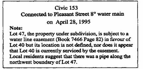
Another example of a surveyor's dilemma is illustrated by the easement description found in Book 7466 at Page 82 in the Halifax County Registry and noted as follows:
"RESERVING NEVERTHELESS a right-of-way over the above described lot to the house on Lot 40 on a plan of part of the Harvey Estate made by E.O. Temple Piers, bearing date March 6th, 1951, for the purpose of maintaining a water line together with the right to enter upon the said lands and to repair and replace the water line as necessity (sic) may require."
A recent plan, shown as figure 3, illustrates the concern that one might have in determining where this water line might be located over the subject lot.
Note on following plan with respect to water line location
Figure 3
Portion of Halifax County Registry Plan # 87802659
Figure 4
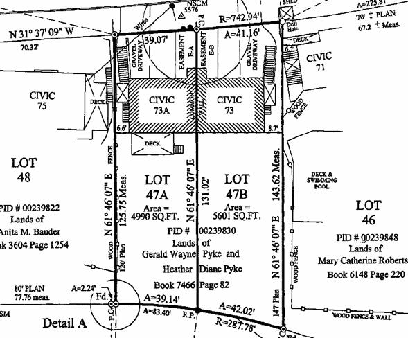
The easement was determined to be located between the common boundary of Lot 47A & 48 and civic 73A based on information provided by local residents. The dwelling that was serviced by the waterline easement obtained a municipal water connection via another street and abandoned the waterline (see figure 4). The easement, however, may remain valid until such time that it is released by the intended user.
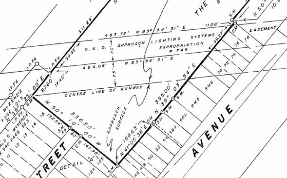
Plan showing existing aerial easement and illustrated on plan #21556 in the Halifax County Registry office
Figure 5
Other easements that provide access over a subject property to an adjacent parcel may be very well described and easily positioned on the ground. The problem that may surface is that the r-o-w which was constructed and in use since the creation of the description is not located within the bounds of the description. Both time and the 'doctrine of estoppel' basically fix the location of the r-o-w as constructed and NOT as described within the title document. It should be noted that poorly described easements are usually a result of the involved parties trying to address an existing concern with little regard of the effects on future generations. Both parties knew what the use was for and where it was located at the time of the easement creation, but like many 'cold case' files, evidence is lost, time passes and interpretations differ.
Figure 5 is an illustration of an aerial easement that existed prior to the survey of the subject property, but was able to be located with accuracy. This particular easement deals with the approach to an airport runway and is a three-dimensional easement that puts restrictions on surface-height development below the vertical description of the originating document.
The location of easements can always be altered by the mutual agreement of the respective parties. The willingness of one of the parties is often swayed by monetary incentives since the desire for relocation is normally one-sided.
is There an Existing Easement Not Documented Properly?
In order for the public record to be as transparent as possible, the land over which an easement passes should have a 'subject to' recital in the property description and the owner of the easement should have a 'together with' recital in their deed description. More than one easement per lot is common in modern conveyances. Such recitals assist the viewer of any property description to readily determine whether the subject lands have an easement as a burden or a benefit. This situation, unfortunately, does not always exist in the real world and the reason why easements are sometimes missed during a title search.
One example I encountered that did not have a 'together with' recital was during the survey of a property in the 1990's for conveyance and mortgage purposes. The property under survey did not contain any recitals as to an easement or r-o-w that would be considered a benefit or burden. All seemed to be in order and it was only on the review of the titled document of the rear and down-slope property, that it was discovered the subject property had an easement over the neighbours property for municipal sewer access. Fortunately, this did not encumber the lot in any manner, but had the lot under conveyance been 'subject to' the sewer line easement, then it might've jeopardized the sale. The easement was not really described very well and in future years may be a problem if maintenance is required.
An easement may have been executed properly, but not recorded in the public registry. This could've been a result of waiting until recording fees were acquired, or that it was felt that the old hat box on the top shelf, or the attic, was a safe spot. Well..... time and following generations sometimes pay little attention to old deeds and mortgages that are covered in dust. Housefires, marital discord and death also played a role in the destruction of what might've appeared to be old and obsolete documents.
It's also quite likely that a conveyance took place and the owners were reluctant to register the deeds since, it would mean receiving a tax bill. Registration under the Registry Act is not mandatory, but certainly advisable. Non-registration usually resulted in a break in the chain-of-title if the document was lost. The heirs awee then faced with having to prove title and accompanying rights. The new Land Registration Act demands that registration take place to ensure title conveyance. All easements that may be a benefit or burden are also required to be listed on the property registry.
If an easement hasn't been recorded, but was properly executed at the time and the document exists, then it can be relied upon. It may not be a problem for the land surveyor to position the easement, but if it wasn't documented properly by the party or parties required at the time, it may not exist. An easement that may not have been properly documented does not necessarily mean the easement doesn't exist, which leads us into the next section of prescriptive rights.
Is There Evidence of a Prescriptive Easement?
What Is the
Responsibility of the Land surveyor?
The land surveyor is the individual relied upon to visit the property, review the documentation and advise the owner of any concerns to the owner being able to enjoy the land as described. This means providing an opinion on the extent of title and subsequently any potential burdens or benefits that might accompany the property. The land surveyor is deemed to be the eyes of the lawyer, realtor, mortgagor and purchaser in the execution of any contract to provided professional land surveying services. Is it possible for an easement to not be recorded or missed in the review of the parcel registry or search of the Registry records? The answer is yes. To err is human and land surveyors and other professionals are no exception. Missing a relevant document can certainly cause a problem, but hopefully that doesn't happen often since most documents are properly recorded.
A prescriptive easement is an easement that is claimed by usage without the benefit of documentation. It may be a simple path over a neighbour's land or a significant roadbed. Either way, the usage must be visible, obvious, and continuous and is supported by the Limitations of Action Act, section 10. Unlike an adverse possession claim for ownership, prescriptive easements only claim a right of usage that would equal the same rights if granted by an easement. The normal period for both adverse possession and prescriptive rights is deemed to be twenty years. If a structure or barrier was involved during the twenty year period, as stated in the Act, a claim for ownership might exist, but continued and unobstructed usage for twenty years or more would certainly be grounds for a prescriptive claim.
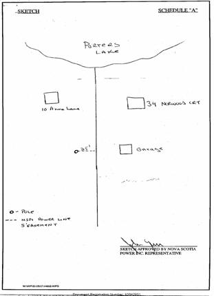
So..... does the land surveyor only look for such activity or evidence when instructed by parties that might have an interest? Unrecorded municipal drainage easements might exist and only be located if a manhole or local drainage outlet is observed. A more obvious type of prescriptive easement is the driveway or old roadbed that may only be used occasionally, but is the sole access to a particular property. Surveys that are done in the winter with snow cover may present a problem for minor trails, but roadbeds are normally still visible. One of the items that is often not considered is an overhead powerline that services an adjacent property or provides service from an adjacent property. An example of a recorded easement not prepared by a land surveyor is illustrated by Figure 6. Note that this easement is controlled solely by the position of the existing utility pole and is intended to service the nearby garage.
Power line easement 25' x 5'
Document 83642901 Halifax County
Registry
Figure 6
In a high density urban core, houses are often separated by only a few feet. There is generally enough room to walk between units, but boundary lines are often very near the dwellings or along the edge of one of the buildings. When looking skyward, it may be observed that the roof overhangs overlap the adjacent structures, resulting in a perceived trespass if mutual prescriptive easements are not considered to exist to accommodate the sometimes 100-year old structures. Even with modern developments, new building structures are built with zero sideline clearances that require an easement over the adjacent land in order to provide building maintenance. All easements restrict the servient tenant from constructing on or altering the easement corridor that would result in obstructing the use by the dominant tenant.
Old urban centers within the city core often present a variety of potential prescriptive easements for driveways since many of the structures predate the automobile. A utility shed in the rear was common with only a possible eight to ten feet between structures. The present usage of such sheds is for residential garages with shared driveways for access. The reporting survey should illustrate the occupational use of any property so that a responsible assessment can be made.
One of the more recent concerns facing the land surveyor and property owners is the existence of wetlands and the restrictions on the use of a property under the Environment Act. The Environmental Goals and Sustainable Prosperity Act passed in 2007 by the Nova Scotia Legislature, states that 12% of the total land mass of the Province has been legally protected in 2015. A policy of preventing net loss of wetlands was established in 2009.
One recent example that I am aware of was an application for a private road to access newly subdivided lots. It was determined that the road would result in an infill situation of the wetland on the property. Various experts were required to give opinions if in fact a wetland existed and how the situation would be dealt with if allowed. The road construction was permitted but only with the installation of 30 culverts positioned every 5 metres. Wetlands exist naturally and their existence is often subject to interpretation and opinion, which is sure to complicate the whole easement scenario in the years to come.
Fred Hutchinson was the Executive Director of the Association of Nova Scotia Land Surveyors from 1999 to 2019 and is a Past President of the Association. Mr. Hutchinson was licensed in 1971, employed by municipal government for nearly six years and spent over twenty-two years in private practice.